TAL & DIARA LANDS
The concept of diara land varies from state to state. All India Co-ordinated Project for Diara land Improvement (AICRP-DI), defined it as:
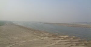
‘Diara’ is the area on either side of rivers like Ganges, Saryu and Brahmaputra etc., which gets flooded with swelling of the rivers and is drained out as the flood water recedes.
Such lands are situated in between the natural levees and get flooded for different periods of time and are periodically eroded and formed due to meandering, sudden movement and course changing of river;
‘Tal’ area may either be flooded through some water courses connecting the main river or even due to heavy rains and they do not drain readily with the receding of flood water.
TAL Land (Focused to Bihar state)
- Tall area suffers continues water stagnation problem during monsoon period and due to lack of drainage facility, delay the drainage of excess water.
- Therefore, cultivation of kharif season crop is not possible due to submergence under 4 to 6 meter deep water and even in winter season, crop also suffers because of stagnation of water and lack of proper drainage.
Bihar- Tall area is mainly located in central Bihar. Mokama taal (lake), is the World’s Largest Tall Region located in the Patna district of central region of the Bihar. It is a group of seven continuous taals. Mokama Tall is a perennial water system and exhibits enormous biodiversity. It is a saucer shaped depression; it runs close to and almost parallel to the right bank of the Ganges. Mokama group of taal lands lies mainly in Patna, Nalanda and Lakhisarai district of Bihar. Mokama tall is the group of seven tall area namely Fatuha, Bakhtiarpur, Barh, Pandarak-more, Mokama, Singhul-sarmera and Barahiya, Minimum area covered in Fatuha taal and maximum area under in pandarak-more taal.

Cropping Pattern and Sowing Period in Tall Areas
- Generally, Tall area is suitable for single crop which is only taken during rabi season so it is known as mono cropped area.
- Here, pulses are good option for farmers, besides linseed, rai and toria are grown as mixed crop with pulse crop.
- In upland tall area, wheat is also grown as mixed crop with gram, where tall land farmers have facility of irrigation through tube wells. They also grow onion and another vegetable crop in their fields during summer season.
Soil Characteristics of Tall Area
- Tall area soils are grey to dark grey in colour, medium to heavy in texture and neutral to slightly alkaline in reaction.
- Soil has less pore space as a result there is high bulk density, poor infiltration rate, and very sticky and plastic character.
- Clay content is dominant and it varies from 50% to 70% throughout the profile. The soils become dry a few days after ploughing.
- Generally tall soils have a good fertility status, organic carbon and available phosphorus is poor to medium in content although available potassium is high in this area.
- About 35-45% soils of this area are deficient in available zinc, 35% soil deficient in boron but 4% in Fe, Mn is found in sufficient amount to meet the need of the crop.
Problems of Tall Lands
- Most of the tall area in submergence condition hence kharif cultivation is not possible. Deposition of silt is another problem which is transported by the river as a result there is clogging of existing ways and collapses the drainage systems.
- Due to delayed drainage, the sowing of Rabi crops is delayed. It provides less time for growth and maturity of the crops, resulting in poor production and inferior quality of the produce.
Diara land
‘Diara’ word comes to ‘Dias’ meaning ‘earthen lamp’ i.e., bowl like land system on either side of the riverbank.
- Diara land are surrounded by the perennial river and subjected to diluvion or alluvion action of that river’. Such lands are known by different names like khadar land, char land, mara land, majha land, dariayi land, kachhar land, riverine area etc.
- Diara land is found on either side of the river and formed due to periodical erosion and deposition of sediments (alluvium) under the influence of meandering and course changing behaviour of the rivers. Such a land form is recognized as one of the most valuable natural resources.
- Occurrence of flood is an annual feature. Erosion and depositions of new sediments take place almost every year during the floods.
Diara land soils
- Undulating landscapes, very light to medium heavy textured, all underlain by sandy layers within 80 to 100 cm of their surface and very well drained to moderately well drained, neutral to slightly alkaline in reaction.
- Fertility status varies widely from poor to very fertile depending upon their physiographic positions but all are under moisture stress due to the occurrence of sandy substratum.
- The soils of diara are excessively drained and constitute layered coarse sands to silt. On uplands crops can be taken for 10-11 months if assured irrigation is provided and in medium land cultivation can be done for 9 months (2 crops can be taken) but low land diara, where crops can be taken for only 7 months. Since crop is being taken in this area as this land remains wet in Rabi and gets too dry during summer.

Soils and Agriculture in Diara Land (Bihar)
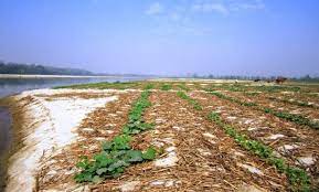
Usually diara lands are available only for a short period, and landless, small and marginal farmers cultivate on these lands the seasonal vegetables and fruits. River bed cultivation of cucurbits is practiced along the river Yamuna, Ganges, Gomti, Sarju and other distributaries in Haryana, Uttar Pradesh, and Bihar.
- The Diara land soils are distributed in an area of more than 11 lakh hectares on both sides of river Ganga, Gandak, Kosi, Sone and subsidiary rivers.
- Diara farmers often resort to mixed cropping as an insurance against crop failure due to flood waters.
- Maize, the most important crops of the area covers the highest proportion of the gross sown area.
- About 65% of total cucurbit cropped area of the country falls under diara lands.
- Banana cultivation is famous of these characterized soils.
- The floating rice is also grown in the seasonally flooded lands in Bihar.
Diara lands of Bihar have potential for agricultural uses. However, such area can be utilized in a better way for development of agro forestry orchards and recreation zones (heritage).
Diara Vikas Yojna
The government of Bihar provides seeds of gourd vegetables, okra, and pea on subsidized rate. Besides, PVC pipe boring has been also promoted upto 100m of 4 inch dm. Government provides assistance of Rs.7500/- per farmer.
Read also…
AGRICULTURE CURRENT AFFAIRS AUGUST 2021